
Every time I cross the bar I learn something important.
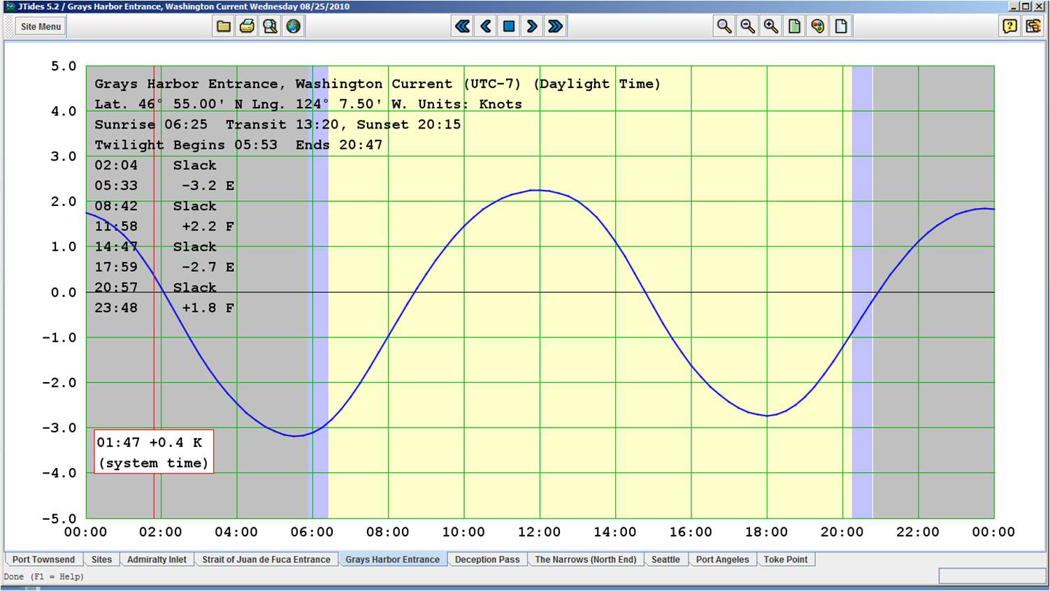
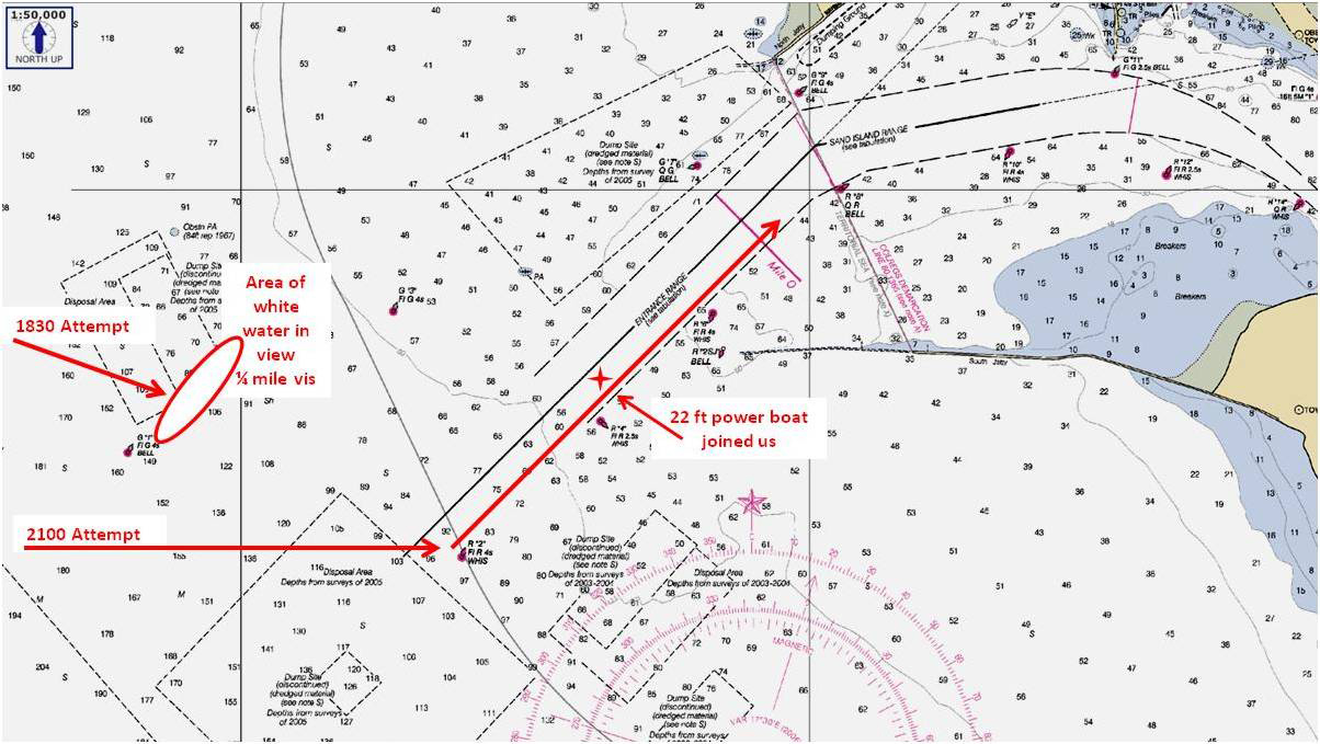
On Wednesday my crewmate and I arrived outside the bar about two hours earlier than planned, having sailed on a brisk broad reach from Westport, WA. My goal had been to arrive about 2000 hrs, which was about 1 hour prior to the next slack before flood...in other words, we wanted to get there towards the end of the ebb, but because of our fast sail we arrived a couple hours early, about 1830, which was maximum ebb.
A goodly NW wind, in the high teens, with 6 foot NW swells and 3 foot wind waves...relatively light conditions, actually. I've crossed in worse, in July a year ago on our outbound trip when the Coasties closed the bar for 26 and under, then closed it for 30 and under, and we waited for them to close it for us, but they never did. The bar can get ugly, especially on the ebb when the incoming waves and wind clash with the outgoing Columbia River. (It can be so ugly that sometimes the bar pilots won't take a container ship across it...but that wasn't the case here.) They call this area "the graveyard of the Pacific" for a good reason.
We had been monitoring Ch 16 to catch bar reports, and the Coasties kept giving the same two pieces of information...a 1530 bar report that said 1-3 foot waves; and that there were "no restrictions on the bar." Outside the bar I called them for most recent conditions...they gave me the same 1530 report, even though I suspected that conditions were radically different because we were then experiencing much greater seas than that outside the bar, and because the ebb was now fully underway. I asked if the information they gave me was from a USCG vessel in the bar, and they said they didn't have "an asset" out there at this time. But they did confirm that there were no restrictions on the bar.
I decided to try the bar and see what the conditions were, and if safe, to continue on in, even though our SOG was going to be just 2 to 3 knots. It was still daylight, even though we were in restricted visibility. Making some progress forward was better than a holding pattern, I thought.
Conditions were 1/4 mile vis in fog, and the seas and wind as stated above. Watching ships and commies on radar ('commies' is the local terminology for commercial fishermen), I approached toward due east, intending to intercept just slightly inbound of the Green "1". Looking ahead, I suddenly saw a line of solid white water across my visible horizon from left to right, less than 500 yards ahead. As we were on a run, we were looking at the windward face of the waves, and I could only imagine what the steep side of the waves would have been. Breaking??? I didn't know and I sure as hell didn't want to find out. So within about 1 second of that view I decided I was absolutely NOT going in there, and I initiated a tack to port, back to a westerly heading. We powered down the main (we were already under reefed main alone), and slowed to about 4 kts, heading west on a close reach, to wait for two hours or so until the ebb settled down.
So here's the most important lesson I learned: that the CG seems not to give bar reports unless they have a vessel out there to report. Makes sense when you think about it, doesn't it? Their ground station only gives you what they last have, properly referring to the time of the last report, but they don't make it clear that the information cannot - nay, should not - be relied upon at 'time now' because wind/wave/swell conditions outside may have changed, and/or because the tidal current cycle has changed. A skipper MUST make his/her own judgments based on very little data absent a CG vessel out there in the bar. (I dread what we would have learned had we run into that white water in the dark.)
We killed time for a couple hours and then headed back to join the channel outside of the Green "1" at about 2100. A slow angle crossing over to the red side, then 2.8 to 3 knots SOG into the current, even at that late point in the ebb cycle, for a not-too-bad ride inbound.
Second lesson, previously learned but dramatically reminded of this time: is not to rush the bar. If there is any wind or waves/swells of size out there, or if it is restricted visibility or if it is getting dark where breaking wave risks can't clearly be identified well in advance, wait it out. Plan for a 'first look' only at slack-before-flood, when the bar is safest, and the flood is coming to 'back up' the slack. (Of course, sometimes the bar is unsafe regardless of tide cycle. It's up to the skipper to find that out himself/herself.)
Inbound, my crewmate said to me in wonder as we passed Buoy 4, in the dark, in fog, "You eat this stuff up, don't you?" With a grin from ear to ear, I replied, "I love it! Sixty-seven years old and still addicted to adrenalin."
I monitor channel 13 in that area because it is the ships that I care about most. We were concerned about a dredge operating near Green "9", which we identified on radar and communicated with, and an outbound tug with two barges in trail, under tow. At about the Red "4", I saw a small boat come out of the fog to our left side about 150 feet away. Then he got really close, and I throttled back and turned about 70 degrees starboard to reduce collision risk. I transmitted a "power vessel to portside of the sailboat at Buoy 4, Columbia River Bar..." message, but no answer. I changed to ch 16, and transmitted same, and the powerboat answered, saying that he was lost with a failed GPS, and if we had good nav gear he wanted to follow us the remaining 8 or 9 miles in to Astoria. What's the name of your boat? "No name." What's your name? "Scott." What kind of boat are you? "A 22 ft North River aluminum fishing boat." I briefed him on our plan, and got him to switch to 13 so he could monitor our conversation. He trailed us until about 4 miles from Astoria when the vis improved and we suggested he could continue on his way...no doubt to tell the story at the 'other bar' later, not about how dumb he was to be out there with only one nav aid, or about how lucky he was to find us, but how awful it was to have to trail a 7 knot sailboat for so long, and that never again does he ever want to go that slow. But let me tell you, considering he was lost on the Columbia River bar, in the fog at night, he was one L-U-C-K-Y son-of-a-gun to have found us.
We got into Astoria's West Basin about midnight, too late to head for that 'other bar'.
Larry Brandt
S/V High Flight #2109
Pacific Northwest, PDX-based
2002 C-36 mkII SR/FK M35B
Wonderful and well written. Thanks for the input.
Stu Jackson, C34IA Secretary, C34 #224, 1986, SR/FK, M25 engine, Rocna 10 (22#)
Thanks for sharing that, Larry. A good and worthwhile read!
Duane Ising - Past Commodore (2011-2012)
s/v Diva Di
1999 Catalina 36 Hull #1777
Std rig; wing keel, M35B, Delta (45#)
Punta Gorda, FL
http://www.sailblogs.com/member/diva-di/