

-
Ok, all you smart math/compass guys, now is your chance to shine.
[B]Here is the experimental set-up:[/B]
1) The boat has a "globe" type magnetic floating compass on the binnacle.
2) The autopilot has a magnetic heading sensor, located under the starboard single seat cushion space.
3) The Garmin GPS has a magnetic heading sensor located under the port transom quarter locker.
4) Both magnetic heading sensors were calibrated to the best of my ability by turning slow circles in calibration mode for each.
4) We are trying to measure the two heading sensor readings (GPS or Autopilot) relative to the globe magnetic compass reading.
[B]Data collection:
[/B]
1) Steer the boat to, say, 000 degrees. wait 5 sec. Record the GPS heading, then record the Autopilot heading.
2) Turn 10 degrees to 010 degrees, record the two headings.
3) Repeat for every 10 degrees around the compass.
4) End up with a data table containing measurements for both GPS and autopilot headings for every 10 degrees around the globe compass.
[B]
Data Crunching
[/B]
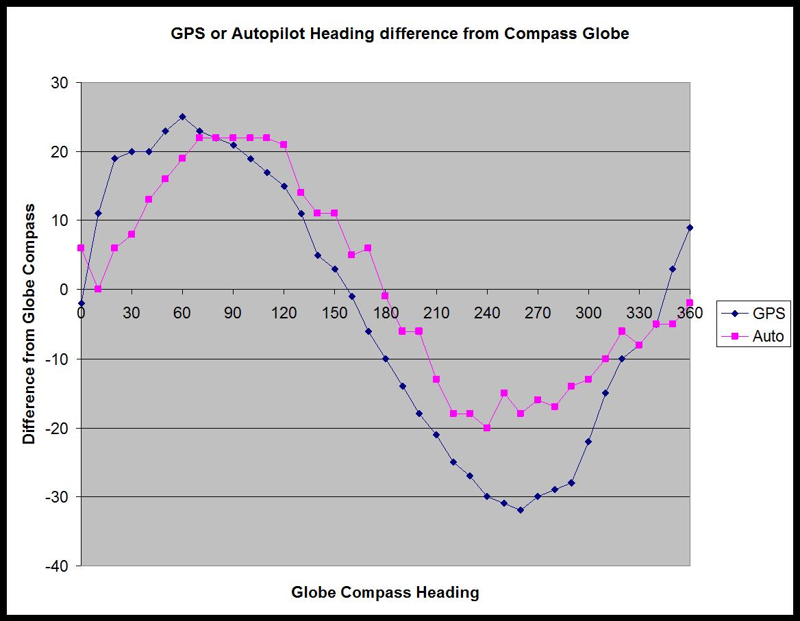
1) Find the difference in degrees between the two heading sensors and the globe compass heading.
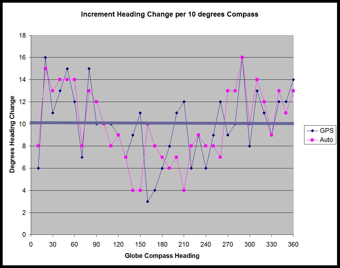
2) Find how much the heading sensors change for every 10 degrees of globe compass change.
3) Make graphs. Look at graphs.
[B]Interpretation of results[/B]
It seems that all three reading agree only at 360 and 180 degrees. At 90 and 270 degrees both magnetic sensor heading are off by around 25 degrees.
Where the sensors should be changing 10 degrees per turn like the globe compass, that change varies from +15 degrees to - 5 degrees.
What is happening here? Is my globe compass off?
What is my true reference? Are both magnetic heading sensors actually correct together?
Does graph 3 show the Deviation?
???
Captain Rick Powers
(USCG OUPV)
1999 Catalina 36 mk II
Hull#1745
Std Rig, Fin Keel
Palo Alto, California
San Francisco Bay
Rick -- I'm extremely interested in this as well. I can't get my three compasses (GPS, autopilot, binnacle) to agree.
I've been thinking of buying a good Suunto sighting compass ($50-100), adding that as a datapoint, and then conducting a test similar to yours.
Maybe that's worth trying as well / adding to your graphs?
Either way, will be really interested in seeing what comes out of your test.
David
s/v Portmanteau
Hull #2133 -- 2003 MKII
Seattle, WA
Rick,
Have you had a professional compass adjuster swing your magnetic (binacle) compass? I did that a few years ago, and he brought some fancy box that contained ?????. With the magic box, he was able to adjust the magnets on the binacle compass, and it was good to within a few degrees on all points. Waaaay beyond my pay grade. Just a thought....
Tom Sokoloski
C36/375IA Past Commodore
Noank, CT
[QUOTE=TomSoko;15167]Rick,
Have you had a professional compass adjuster swing your magnetic (binacle) compass? I did that a few years ago, and he brought some fancy box that contained ?????. With the magic box, he was able to adjust the magnets on the binacle compass, and it was good to within a few degrees on all points. Waaaay beyond my pay grade. Just a thought....[/QUOTE]
BINGO!!! You need the magic box and a professional. Takes about an hour+ and should run about $100.00 - $200.00.. He will leave you with an accurate deviation card.
-Maine Sail
https://www.marinehowto.com/
A couple of things. First, you have one graph that is referenced to Gyro Heading, but you haven't defined what that is; and 2) a 'GPS heading' is NOT a heading at all, but is actually a COG, and as COG it is therefore subject to any 'slip slidin' away', as the old song says.
Heading is defined as where on an accurate magnetic compass the boat is pointed. In any current, that alignment might be visible for only a few moments before the current moves the boat to another location. While GPS cannot provide Heading, aligning the boat with streets on a hillside (after computing what the mag layout of the streets is) can provide heading, and then you can use a pelorus to align to any other angle...if in no current. If you don't have a pelorus, I suppose one can be fabricated out of basic materials, such as plywood.
I third the suggestion of getting a professional to swing the binnacle compass.
Larry Brandt
S/V High Flight #2109
Pacific Northwest, PDX-based
2002 C-36 mkII SR/FK M35B
Maine Sail, just what is the 'Magic Box' that the compass adjusters use?
Larry Brandt
S/V High Flight #2109
Pacific Northwest, PDX-based
2002 C-36 mkII SR/FK M35B
If any of you are a power squadron member they have a class in how do adjust your compass. It is well worth it and you get the pleasure of adjusting your own compass if you like. It will teach you how to set up a deveation chart. The class I took had a magic box they would loan you if you were a member.
Randy Sherwood
Mutualfun 1990 # 1057
T/R W/K M35a
Home. Charlotte, Mi.
Boat. St Augustine,Fl.
Hi Larry (and all),
Thanks for the comments.
Yes, the GPS uses a gyro heading sensor, not COG. Same with the Autopilot.
Today I went out and did one more test and data collection.
I placed a hand-held compass away from the binnacle, over on the side lazerette.
Now, again, at every point (10 degrees) on the binnacle compass I recorded the readings on the hand-held compass and the GPS and Autopilot heading sensors.
THE ANSWER:
It is clear that the hand-held compass agrees with both gyro sensors, and [B]the odd-man-out is the binnacle compass.
[/B]
I'll look into having a compass guy come out.
Will report back...
Captain Rick Powers
(USCG OUPV)
1999 Catalina 36 mk II
Hull#1745
Std Rig, Fin Keel
Palo Alto, California
San Francisco Bay
[QUOTE=LCBrandt;15171]Maine Sail, just what is the 'Magic Box' that the compass adjusters use?[/QUOTE]
A very expensive portable gyro compass. They also use a magnetometer and some other tools too...
Please also keep in mind that with the trend for electrics within inches of the compass some can not even be swung. This is especially true with the disturbing move towards magnets in the doors of chart plotters eg: Garmin, Raymarine, Lowrance etc. etc..
Our compass is swung with deviation cards for electronics ON and electronics OFF. However, we were hit by lightning and that threw our compass off after the strike. So its not just electronics that get toasted by lightning compasses can get pooped too.
-Maine Sail
https://www.marinehowto.com/
.
Compensation. That's what the problem is!
I spoke with a compass guy.
He said that it sounded like the compensation was off.
Simple to adjust:
_______________________________________________________________
A built-in correcting magnet system, standard on all compass models, consists of two sets of magnets fixed to two adjusting rods with slotted ends. The slots should be horizontal before starting the adjusting procedure. A small non-magnetic screwdriver is provided for this purpose. On bracket and deck models, the black plastic inserts must be removed to gain access to the slotted compensator rod ends. Before starting compensation, check the area around the compass to make sure all material of a magnetic nature is secure and in its sea-going position. Through the years, many methods and devices have been used to compensate compasses, such as gyros, azimuth circles, sextants, or a pelorus. However, we are going to show you one simple, yet effective method, using equipment that you should have on your boat, and another method using equipment you might have on your boat.
Step one. With the compass in its intended position, but not finally secured, select a course on your chart using two identifiable marks, buoys or landmarks that are within ten degrees (10°) of the North/South line. Try to select this course so that you can maneuver your boat "down range" of the marks selected (See example).
Step two. From a position down range of the North/South marks, and keeping the marks lined up, run the boat visually along the Northerly course selected. Turn the port/starboard compensator until the compass reads correctly.
Step three. Reversing direction, run the boat Southerly, again keeping the marks lined up. If the compass is not correct at this time, there is an alignment error. To correct, rotate the compass itself to remove one half of this error. Repeat Steps 1 and 2 and then recheck this Step 3.
Step four. Simply repeat the procedures of Steps 1, 2 and 3, except this time, using and East/West course and the fore/aft compensator, although at this time any alignment error should have been eliminated.
Step five. Upon completing the procedure, secure the compass in its final position.
________________________________________________________________
I'll let you know how it goes after adjustment -Rick
Captain Rick Powers
(USCG OUPV)
1999 Catalina 36 mk II
Hull#1745
Std Rig, Fin Keel
Palo Alto, California
San Francisco Bay
From a purely "navigational" POV, it IS important.
From a LOCAL sailing POV, it simply doesn't make any difference.
Why?
'Cuz I've been sailing these same waters for 35 years, and those differences do not make any, well, difference. The distances we sail are not great enough to make a difference.
The reliance, or suggestions to match the binnacle compass with the fluxgate compass, is something that MS covered very well.
Because of this thread, I compared them when out sailing yesterday and today.
Deviation of the binnacle compass, I believe, accounts for the difference between it and the fluxgate, 'cux in one direction yesterday they agreed, but today coming downwind they didn't.
Do I care? For short distances in clear visibility, no.
If I was doing serious navigation, and faced with fog in Maine, or offshore sailing, I WOULD reconcile the issue.
I submit that most of us, and the sailing we do, may not justify the differences.
Head down now, waiting for the flames. :eek:
Stu Jackson, C34IA Secretary, C34 #224, 1986, SR/FK, M25 engine, Rocna 10 (22#)